Here's how to use geotagging to add location data to your image files.
Here's how to use geotagging to add location data to your image files.
Dave Johnon
PCWorld
I remember showing photos of my trek through Grand Cayman to a friend a few years ago. "Where were these taken?" she asked me about a particular set of photos. "Hmm," I replied, "I don't remember. The East End, I think. I took so many photos, I can't keep track." At the time, I wished there was some automatic way to tag my photos with location information, so I'd always know where they were taken. Yet another thing I'd never have to remember ever again!
Well, my wish has come true: Geotagging is here. Geotagging is the term for adding location information to your photo files--and it's one of the coolest things ever to happen to digital photography.
The Magic of GPS
How can a camera know where it's taking photos? With the Global Positioning System, of course! The system of navigational satellites that a lot of people now take for granted also lets you geotag your photos. In a perfect world, GPS chips would be built into all digital cameras. But that's not the case right now. Instead, we need to somehow marry GPS and photography to make geotagging work.
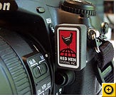
The available solutions range from amazingly elegant to somewhat less elegant. Take Red Hen's Blue2Can, for example. In my experience, there's no better geotagging solution.
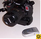
Blue2Can is a thumb-sized gadget that plugs into a small port on the front of several Nikon digital SLRs, including the D200, D2X, D2Xs, and D2Hs. It communicates wirelessly to any Bluetooth GPS receiver, like the kind that sits on your car's dashboard, the clip-on GPS device that I reviewed in May, or the Pharos gadget that combines multimedia features with GPS.
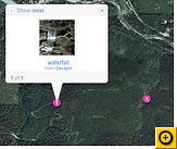
Blue2Can automatically tags your photos as you take them with GPS data (latitude, longitude, and altitude) that mapping software can read. Take a few pictures with Blue2Can attached to a Nikon camera, then upload them to your Flickr page, for example. Flickr adds a "map" link to each picture--click it and you can see where it was taken. Even cooler: You can view all your photos as pushpins on a map, so you can go on a virtual tour of that Grand Cayman vacation.
Manual Geotagging
But what if you don't have a Blue2Can-compatible Nikon camera? You can add location info after the fact. To do that, carry a GPS receiver with you while you shoot, and then use a program on your PC to synchronize the GPS data with your photos. RoboGEO is a clever program that can read the log from your GPS receiver and mark all your photos with the appropriate locations. And Sony has a gadget custom-designed for just this sort of track-your-movements photo duty, the GPS-CS1.
It is a pretty simple process, but it does involve an extra step to batch-process all your photos when you get them home.
If you aren't quite ready to step into the world of GPS, there are ways to mark your photos with locations manually. In Flickr, for example, you can display a photo and click the link labeled "Place this photo on a map" to pick a location off a map by hand.
It's not as glamorous as letting a billion-dollar military satellite system do it for you, but the end result is the same: You and your friends can see the photos were taken.


No comments:
Post a Comment