I have been inspecting the results of the registering of my collections, aka catalogs, of geoEXIFed imagery placed into Google Earth by several pathways. To frame this story -
I have a tad over 11,000 geoEXIFed and other geo-tagged images collected during the last decade. My spatial image inventory has been collected with the various Red Hen Systems tools. Recently I have also been collecting from the WEB goe-spatial images shared via Flickr and Google Earth. I have also used Picasa.NET to move reospatial images around.
I also have spatial video, maybe 120 hours in aggregate - I have a couple of legacy tapes pending as my "one/first" Maxtor external 250GB external is pretty much full-up. With much procastination, blood, sweat, tears, and hours I have so far sucessfully rendered that stack of video down to 28 clips totalling 135 minutes of 30fps NSTC, PAL and MPEG-2 videos explaining maybe four or five stories or themes. Today, I am browsing that imagery via Picasa.NET and Adobe's Lightroom Beta. I have leared to be reasonably productive with Adobe Premier for the video. Red Hen imagery and video mapping products have contributed the spatial slice-and-dice environment as well as generation of ESRI personal geobase, HTML and Flash cartographic work-products. How many CODECs? Wouldn't bet it was less than a half-dozen? I want to find an easy way to do the same within Google Maps.
I was able to join in Picasa NET Beta some months ago and was excited when I found the "Geotag > View in Google Earth" Tool option. It didn't initially work (accept images) but offered the opportunity. Today the "View in Google Earth" Picasa.NET option does a reasonable job although in some places it is still a bit rough IMHO - like no obvious "Blogger" map in this Beta . While I can not fully endorse Picasa, the more I use it the better the results I get. The .NET version remains in Beta, you'll need to have a gmail account, and expect an update say every three to six weeks?
My 11,000 geotagged images come with all sorts of legacies, collection methods, GPS accuracies, and geoEXIFing method. These are a few of the sources that can contribute positional wobble and uncertainty to an image's absolute position. How much accuracy does a geo-photo require? It depends. And when combined, these errors and those found within Google Earth/Maps and the GIS sciences generally, sometimes disappoint expectations. I too have been disappointed and to channel frustration, I am trying to understand the various sources of pure bias, trend, and residual error as a worthy interest. For the GISer this is table-speak as we are longer toothed on issues of GPS and how to lie with maps. To better understand camera wobble - the photography domain I seek illumination. The next several notes following will try to explain what I have seen and what I think may be going on.
GPS WObble
In the "old" days, before WAAS and when SA=ON, GPS position was guaranteed to be 100 meters off at any time (2RMS) and as much as 300 meters off on the 3RMS+ extremes. My posting experience suggests that the GPS WObble for that era was more typically 20-40 meters.
More recently, GPS accuracy has improved from 100 to three meters, cost per device are under $150, and form is the size of a matchbook. My preferred GPS solution these days are SiRFstarIII chip-sets which delivers 20-channel, massively correlated and WAAS corrected NMEA strings over Bluetooth.
What sort of accuracy should we expect with current SiRFstar III Bluetooth GPS devices? There are many relative and absolute position qualities I could digress to but for now lets assume good WGS84 certainty at the street level. The GPS accuracy is a positional accuracy of a few meters. An operationally good GPS condition would indicate PDOP is low (<2),>6), each with matching RTCM differentials that are both tight in space and latency. These conditions when matched to smart GPS software calculating an over-determined solution, the SiRFstarIII chip-set should be delivering antenna location in WGS Lat/long six decimal precision to within three meters at 2RMS and under one meter CEP or half the time. Is this good enough? One meter gets you there when ten will not? Seems good for me but maybe a serious geo-cacher might drop in on us and set the story right? As for elevation error or noise, a rule-of-thumb is 2-3 times the X/Y 2RMS error.
In my spatial image collection, a good portion have PDOP as well as the presence or absence of the WAAS or other RTCM differentials. These are indices of GPS performance. For some elite catalogs with well populated EXIF headers there will be images with orientation, distance to POI, edition information, image adjustment, and other tags. In some cases, the image might have associated sensors and both their data records plus their meta data. Neither that fit well a standard EXIF structure. In this case, innovation has required a GPS "LOG" or companion files that includes both NMEA and $ proprietary strings.
Squinty Eyes and Picture WObble
As far as resolution of my geoEXIFed catalog, I have lots of VGA, 1.3 mega pixel, and five mega pixel JPEGs. I have five mega pixel hand-camera for years now and have almost gone SLR at home. As a point-and-shoot pointographer the sweet-spot 3.5 mp image seems the more likely adjustment via my next smartphone. I have used many versions of Nokia camera phones and have a Fuji five mega pixel FinePix must be four years old now. Its handled the abuse well although I have acquired some sort of fungus that is devouring something that supports the display. Pixels are dieing in a hyphael pattern. I am learning how to improve poor images. Picasa is does an Ok job but I prefer the feel, organization, and quality offered in Adobe's Lightroom Beta. I know how to fix some of the issues of digital camera error - white balance, lens jitter, lighting issues, and other cool stuff I too can move sliders and embellish "my" imagery.
Hard-knocks experience tells me its time to move beyond JPEG or even JPEG2000. I like what Microsoft is doing with SeaDragon, Windows Media Photo and Photosynth. These are products from their Media Lab's propeller heads and will soon appear with Microsoft's next-generation of OS.
I also have some other odd-sets received mostly from friends - all but a scant few via CD. I a very small but growing inventory of images received from the Internet via sharing. I really like immersive imagery and when well-done, I could digg 3D. So much so watch this space for more on 3D-immersion! I only print to paper a small number of images say 1:500. I am starting to get quite excited about the sharing of images as a digital proxy for paper printing.
I am certain I am finding location wobble that likely others have or are facing both knowing and not. This "wobble" should be considered a new source of lens jitter in digital imaging. Solution? Good technique and/or innovative technology can minimize this. Further each method to geoEXIF the image have both common sources of error and well as significant limitations.
I want an easy way to minimise duplication of my media. But I also want a reliable way to re-organize my work products to my camera phone and allow easy creation of CDs, DVDs, and external disk storage for my use and for my clients. I am finding it too easy in my processing to create duplicates. Worse is the related fear to delete something you know you don't need but are uncertain if you have consolidated all of the changes... and other subconscious Delete - are you certain? fears. And duplicates in Picasa are very confusing IMHO. The have a stub for dupes but I have yet to see a understandable result. So I will await the update?
Thursday, October 26, 2006
Tuesday, October 17, 2006
Symbian Personal Navigation and Bluetooth GPS Transceivers
The Bluetooth GPS Transceiver (BtGPS) has a very high utility if you can demonstrate a must-have personal navigation device/solution. Interested? And navigation, I have heard is the necessary base of many rather cool LBS services .... soon to come.... someday?
Adding a BtGPS device to your "mobile" kit will cost around $100 and will be connected to your Symbian Series 60 with Bluetooth features in a few minutes. Then if your smartphone includes a "data plan" that provides you mobile Internet access, well, from that moment on and depending how you adapt to yet another blinking light and its battery hassles, you can:
- find where you are,
- locate where someone else is,
- review where you have been,
- calculate the best way of getting where you want to go, and
- recall places or faces of interest you have found or want to find.
- plus WiFi hotspot radar?
ALL with a geotagging positional tolerance of a only a meter or three.
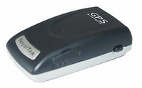
While there are many BtGPS devices, a MidNight recommendation would include "SiRF" and its chipset SiRFstarIII. These 20-channel, WAAS capable, and massively correlated devices can deliver a 2 meter CEP in low PDOP conditions. Bluetooth positional error of dilution is no greater than 10 meters most conditions. Main differentiations will be blink-blink, battery size, and stuff like TTFF CS and WS. I prefer RoyalTek RBT-2001 due to its smarter and compact implementation, TTFF CS, TTFF WS, and battery selection (identical to most Nokia handsets - 0.700 amp/hr). The RoyalTek's use of an easily-had NiCad battery offers an alternate charging path for the same battery form (12-15v cigarette plug step-down to 5-volt PDA/PND plug-end) which has rescued dead and dieing mobiles too many times to be dismissed.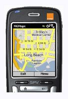 Once you have the BtGPS figured out, I am encouraging you to immediately download a copy of the MGmaps. It is a very excellent personal navigation device application for your Symbian 60 smartphone. Its a get your map anywhere/anytime via downloading Google Map streets and satelite images via the Google Mobile design.
You can also render the Nokia/Symbian application on your PC just to see it do its thing. You'll need to first check your JAVA and then likely download a JAVA set from the page below...
And you can share KMLs TOO!
Tuesday, October 10, 2006
Navman's NavPixs and IsWhere
 Navman has created a rather nifty PNA (personal navigation assistant) that combines auto-routing to geotagged images. Select the place of interest via the photo-base and a route from where you are to the image place is routed for you.
Monday, October 09, 2006
Google Earth and IsWhere

IsWhere permits any selected geoEXIFed images to be viewed in Google Earth. These images we collected with GPStagIT. For example any geoEXIFed image created by the Nikon DX2 or Ricoh Spatial Cameras can be so posted.
Subscribe to:
Posts (Atom)


