US Topo
Topographic Maps for the Nation
Mark Newell
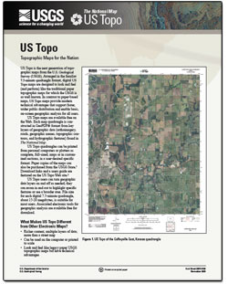 US Topo is the next generation of topographic maps from the U.S. Geological Survey (USGS). Arranged in the familiar 7.5-minute quadrangle format, digital US Topo maps are designed to look and feel (and perform) like the traditional paper topographic maps for which the USGS is so well known. In contrast to paper-based maps, US Topo maps provide modern technical advantages that support faster, wider public distribution and enable basic, on-screen geographic analysis for all users.US Topo maps are available free on the Web. Each map quadrangle is constructed in oPDF® format from key layers of geographic data (orthoimagery, roads, geographic names, topographic contours, and hydrographic features) found in The National Map. US Topo quadrangles can be printed from personal computers or plotters as complete, full-sized, maps or in customized sections, in a user-desired specific format. Paper copies of the maps can also be purchased from the USGS Store. Download links and a users guide are featured on the US Topo Web site. US Topo users can turn geographic data layers on and off as needed; they can zoom in and out to highlight specific features or see a broader area. File size for each digital 7.5-minute quadrangle, about 15-20 megabytes, is suitable for most users. Associated electronic tools for geographic analysis are available free for download |


No comments:
Post a Comment